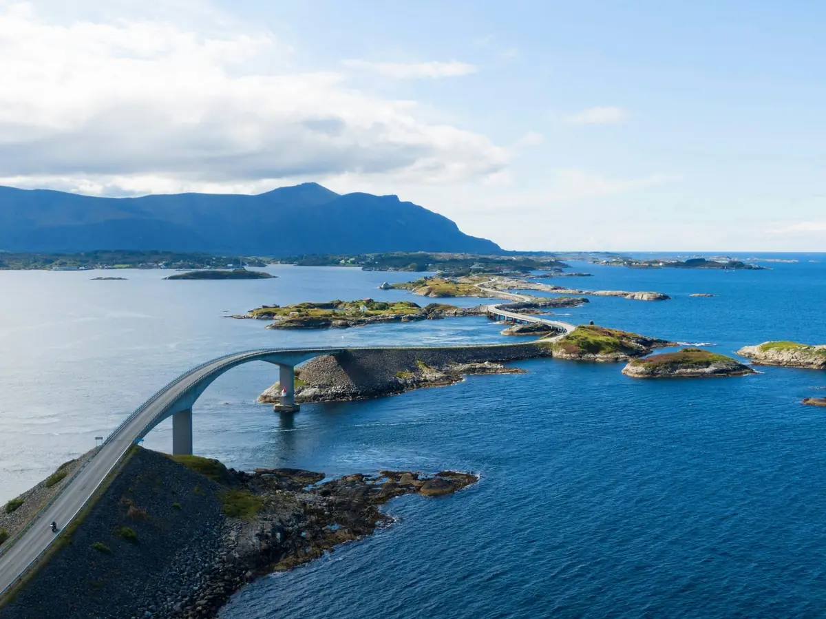
Northern Møre og Romsdal offers a very different side of Norway.
Instead of enormous fjords and high mountain passes, this part of the country is shaped by: open Atlantic Ocean, small islands, fishing villages, bridges, coastal roads, traditional seafood, maritime history, windswept landscapes.
At the centre of this coastal region is Kristiansund, a colourful island city historically connected with fishing and the production and export of dried and salted cod, known as klippfisk.
From Kristiansund, travellers can explore the historic fishing village of Grip, the island landscapes of Averøy, the famous Atlantic Road and a spectacular stretch of coastline extending toward Molde and Bud.
The official Norwegian Scenic Route between Kårvåg and Bud is approximately 36 km long and forms one of Norway's designated 18 Scenic Routes.
12.1 Kristiansund at a Glance
- Region: Møre og Romsdal
- Area: Nordmøre
- Main character: Coastal island city
- Known for: Klippfisk, Sundbåten, Grip and Atlantic Road
- Best for: Coastal culture, seafood, photography, road trips and island excursions
Kristiansund is built across several islands and is traditionally described through its four main island communities: Kirkelandet, Innlandet, Nordlandet, Gomalandet.
The city's island character is one of the first things visitors notice.
12.2 The Four Islands of Kristiansund
Kristiansund's geography is central to its identity.
Rather than being built around one continuous mainland centre, the city developed across islands connected by roads, bridges and boats.
This creates a distinctive coastal atmosphere.
Kirkelandet — the main urban centre. Here you will find shops, cafés, restaurants, cultural attractions, harbour areas, modern city services.
Innlandet — a quieter historic island with attractive older buildings and harbour views.
Nordlandet — a residential and historic part of the city.
Gomalandet — home to the Norwegian Clipfish Museum and important parts of Kristiansund's fishing heritage.
12.3 Sundbåten
One of the easiest ways to experience Kristiansund's island geography is by using Sundbåten.
The small passenger boats connect the city's islands and have become an important part of the city's identity.
Visit Norway describes Sundbåten as a historic local transport service connecting Kristiansund's islands.
Why take the Sundbåten? It is useful for short island-to-island journeys, harbour photography, experiencing local transport, seeing the city from the water.
Check current routes and operating information before travelling.
12.4 Klippfisk — The Taste of Kristiansund
Kristiansund's history is strongly connected with klippfisk.
Klippfisk is traditionally produced from salted and dried cod.
The product became an important part of the city's maritime economy and remains an important part of local food culture.
Try local dishes: bacalao, klippfisk, fresh cod, local seafood, fish soup, traditional Norwegian desserts.
A seafood meal is an important part of the Kristiansund experience.
12.5 Norwegian Clipfish Museum
The Norwegian Clipfish Museum is located in a historic wharf environment on Gomalandet.
It explains the importance of salted and dried fish to Kristiansund's economic and cultural development.
The historic wharf dates back to the 18th century, making the location itself part of the experience.
Recommended time: allow approximately 1–2 hours.
Combine the museum with: Sundbåten, harbour walk, lunch, city centre sightseeing.
12.6 Varden Viewpoint
For a quick panoramic view of Kristiansund, visit Varden.
The viewpoint stands approximately 78 metres above sea level and offers views across: Kristiansund, surrounding islands, the open sea, Grip, Smøla in the distance.
Photography: Varden is particularly useful for understanding the city's unusual island geography. A wide-angle smartphone photograph can capture the relationship between city + harbour + islands + ocean.
12.7 Kvernberget
For visitors who want a short walk close to the city, Kvernberget is another option.
The summit is approximately 205 metres above sea level.
Visit Norway describes the hike as relatively easy, with roughly 20 minutes of walking one way under suitable conditions.
This can be a good alternative to a longer mountain hike.
12.8 Grip — The Fishing Village in the Atlantic
One of the most memorable excursions from Kristiansund is a trip to Grip.
Grip is a tiny historic fishing village located out in the Atlantic Ocean, approximately 12–14 km northwest of Kristiansund, depending on the reference point used.
The settlement provides a glimpse into the traditional life of Norway's exposed coastal fishing communities.
12.9 Grip Stave Church
One of Grip's most important historic landmarks is its small medieval stave church.
The church dates from the Middle Ages and is one of the reasons Grip has such strong cultural and historical value.
On the island, visitors can explore: colourful wooden houses, narrow paths, fishing heritage, the church, coastal scenery, harbour areas.
12.10 Visiting Grip
Grip excursions are seasonal.
The Grip boat runs in the summer season only.
Season dates and departure times change from year to year, so check the current Grip timetable with Visit Kristiansund before travelling.
12.11 Why Grip Is Worth Adding
Grip is not simply another sightseeing stop.
It demonstrates how Norwegian coastal communities historically adapted to: harsh weather, fishing, limited land, isolation, maritime transport.
For travellers interested in Norwegian culture rather than only scenery, Grip adds valuable depth to the trip.
12.12 Smøla
North of Kristiansund lies Smøla, a low-lying island municipality famous for its coastal landscape and wildlife.
The area is particularly associated with white-tailed sea eagles.
Visit Norway highlights Smøla's exceptionally dense sea-eagle population and the possibility of eagle safaris.
Best for: wildlife photography, birdwatching, cycling, coastal landscapes, fishing, quiet island experiences.
Smøla works particularly well for travellers who want to move beyond the most famous tourist attractions.
12.13 Veiholmen
At the northern end of Smøla is the distinctive fishing village of Veiholmen.
The journey through the island landscape itself is part of the experience.
Expect: small roads, bridges, rocky coastline, fishing boats, colourful houses, open ocean views.
It is an excellent destination for slow travel and photography.
12.14 Averøy
Averøy connects Kristiansund with the Atlantic Road.
The island municipality provides a transition from urban coastal Norway to the exposed ocean landscape of the Scenic Route.
Highlights include: Kårvåg, Kvernes, coastal hiking, fishing, Håholmen, Atlantic Road.
12.15 Kvernes Stave Church
One of the cultural highlights of Averøy is Kvernes Stave Church.
The church represents the region's medieval religious heritage and provides an interesting cultural contrast to the modern engineering of the Atlantic Road.
Suggested combination: visit Kvernes → Kårvåg → Atlantic Road. This creates a day that combines history + landscape + engineering + ocean.
12.16 Håholmen
Near the Atlantic Road is the small island community of Håholmen.
It is associated with coastal history, maritime culture and accommodation.
The island can be reached by boat from the Atlantic Road area during the appropriate season. Visit Norway currently notes regular summer boat service, with the journey from the road taking only a few minutes.
Stay overnight? For a memorable coastal experience, consider spending a night here instead of simply making a short stop.
The island atmosphere can be especially appealing in summer, calm weather, shoulder season.
Check seasonal boat schedules before booking.
12.17 The Atlantic Road
The Atlantic Road is the signature attraction of this chapter.
The official Scenic Route runs from Kårvåg → Bud and covers approximately 36 km.
The route crosses islands and skerries using bridges and causeways, bringing travellers exceptionally close to the Atlantic Ocean.
The road was opened in 1989.
12.18 Atlantic Road Bridges
The route's engineering is one of its main attractions.
The road crosses the ocean landscape using a series of bridges.
The most famous is Storseisundbrua — this is the iconic curved bridge seen in many photographs of the Atlantic Road.
Its unusual shape can make the road appear to rise dramatically toward the sky depending on the viewing angle.
Photography tip: do not photograph only from inside the car. Use the designated viewpoints and walking areas to capture bridge, ocean, surrounding islands, road curves, changing weather.
12.19 Eldhusøya
Eldhusøya is one of the best stops along the route.
A raised circular walking path surrounds the island and provides panoramic views of the ocean.
The Norwegian Scenic Routes authority describes the path as accessible to all.
Allow approximately 30–60 minutes depending on how often you stop for photographs.
12.20 Myrbærholm Bridge
Myrbærholm is another important stopping point.
Fishing opportunities are available around the bridge area, and the location provides close views of the sea.
The official Scenic Routes information specifically highlights fishing around Myrbærholm.
Bring: fishing equipment if permitted, waterproof jacket, warm layer, camera, non-slip footwear.
The wind can be surprisingly strong.
12.21 Askevågen
Askevågen offers another opportunity to experience the ocean at close range.
A small viewpoint and coastal facilities allow travellers to stop and observe the sea.
The experience changes dramatically with weather.
Calm weather: blue water, seabirds, small islands, reflections.
Stormy weather: waves, sea spray, dramatic clouds, powerful Atlantic conditions.
Never approach the edge simply to obtain a more dramatic photograph.
12.22 Farstadsanden
The area around Farstadsanden offers coastal walking opportunities.
This is a good alternative for travellers who want to get out of the car and experience the landscape on foot.
The official Scenic Route information highlights the coastal trail around Farstadsanden and Vevang.
12.23 Vevang
Vevang sits near the western section of the Atlantic Road.
It provides access to: coastal trails, sea activities, fishing, diving, photography.
The area is particularly attractive to outdoor travellers.
12.24 Diving & Sea Activities
The Atlantic Road region offers opportunities for: fishing, kayaking, diving, snorkelling, RIB trips, wildlife experiences.
Local operators may offer organised excursions, including fishing and seal-related activities.
Safety: the Atlantic is cold and weather conditions can change rapidly. Only participate in diving or other technical water activities when properly trained and equipped.
12.25 Bud — The Western Gateway
The official Atlantic Road Scenic Route ends at Bud, a historic fishing village.
Bud is a natural place to stop after crossing the island-and-bridge landscape.
Explore: harbour, coastal paths, historic fishing environment, Ergan Coastal Fort, open-ocean viewpoints.
12.26 Ergan Coastal Fort
Near Bud is the Ergan Coastal Fort area.
It provides historical context for the strategically important Norwegian coastline.
Combine a visit with: Bud harbour, coastal walking, photography, a seafood meal.
12.27 Atlantic Road in Different Weather
The Atlantic Road is unusual because the same route can look completely different depending on weather.
- Sunny day: blue water, bright islands, long visibility, calm photography conditions.
- Cloudy day: stronger contrasts, dramatic skies, atmospheric photographs.
- Stormy day: the landscape can become extremely dramatic, but storm conditions also require additional caution.
Important: do not stop in dangerous locations just because waves look impressive. Use official parking and viewing areas. The Scenic Routes authority specifically advises visitors to park only at designated stopping places.
12.28 Cycling the Atlantic Road
The Atlantic Road is also part of Norway's coastal cycling network.
The official Scenic Routes information notes that the route forms part of National Cycle Route 1 and coincides with the EuroVelo 1 Atlantic Coast Route on the Bergen–Nordkapp section.
Cycling challenges: be prepared for strong wind, traffic, bridges, changing weather, limited shelter.
The route can be rewarding, but cyclists should plan carefully during high season.
12.29 Family Travel
The region can work very well for families.
Easy experiences: Sundbåten, Varden, Atlantic Road viewpoints, Eldhusøya, Bud harbour, seafood restaurants, selected museums.
More adventurous: Grip excursion, cycling, fishing, kayaking, wildlife trips.
Families should check minimum ages and weather restrictions for organised boat activities.
12.30 A 1-Day Kristiansund Itinerary
- Morning: 09:00 breakfast in Kristiansund, 10:00 Sundbåten/harbour exploration, 11:00 Clipfish Museum.
- Afternoon: 13:00 lunch with bacalao or local seafood, 14:30 Varden viewpoint, 16:00 Kvernberget or relaxed city walk.
- Evening: 18:00 seafood dinner, 19:30 harbour photography.
12.31 A 2-Day Kristiansund & Atlantic Road Itinerary
Day 1 — Kristiansund: Sundbåten, Clipfish Museum, Varden, city centre, seafood dinner.
Day 2 — Atlantic Road: Morning — Kristiansund → Kårvåg. Midday — Kårvåg → Geitøya → Eldhusøya. Afternoon — Storseisundbrua → Myrbærholm → Askevågen. Evening — Bud. Stay in Bud, Hustadvika or continue toward Molde.
12.32 A 3-Day Coastal Experience
- Day 1: Kristiansund.
- Day 2: Grip excursion.
- Day 3: Atlantic Road → Bud.
This itinerary works particularly well during the summer season when Grip excursions are operating.
12.33 A 4-Day Slow Travel Route
- Day 1: Kristiansund.
- Day 2: Grip.
- Day 3: Averøy + Håholmen.
- Day 4: Atlantic Road → Bud → Molde.
This version gives more time for photography and coastal experiences.
12.34 A 5-Day Northwest Coast Route
- Day 1: Kristiansund.
- Day 2: Grip.
- Day 3: Averøy + Kvernes + Håholmen.
- Day 4: Atlantic Road + Bud.
- Day 5: Molde or onward toward Åndalsnes.
This is an excellent extension to the Romsdalen chapter.
12.35 Kristiansund to Molde
The coastal connection between Kristiansund and Molde can form part of a larger road trip.
Possible sequence: Kristiansund → Atlantic Road → Bud → Molde.
Visit Norway notes that bus and boat connections operate throughout the Northwest region, while road travellers can connect the main destinations by car.
For independent travellers, a rental car gives the greatest flexibility for viewpoints and photography stops.
12.36 Kristiansund to Ålesund
A longer Northwest itinerary can continue: Kristiansund → Molde → Åndalsnes → Ålesund.
This links several major attractions: Atlantic Road, Molde Panorama, Romsdalen, Trollstigen area, Geiranger region, Ålesund.
Check current road, ferry and seasonal conditions before choosing the exact route.
12.37 Getting to Kristiansund
By plane — Kristiansund Airport provides connections to major Norwegian destinations. Visit Norway currently lists regular connections involving Oslo, Bergen, Trondheim and Ålesund.
By car — from Trondheim: E39 → Northwest. From Oslo: routes can be planned via the E6 and onward west, depending on the destination.
By sea — coastal services also connect the region. Hurtigruten and other coastal services provide another way to experience the Northwest. By bus — regional and express bus services connect Kristiansund with Molde and other destinations.
Always check the current timetable before booking.
12.38 Where to Stay
- Kristiansund — best for: city sightseeing, Grip, museums, restaurants, public transport.
- Averøy — best for: Atlantic Road, fishing, Håholmen, outdoor activities.
- Hustadvika — best for: Atlantic coastline, coastal walks, sea activities, peaceful accommodation.
- Bud — best for: fishing-village atmosphere, coastal scenery, history, photography.
12.39 Food Guide
Must-try: bacalao — a classic dish strongly associated with Kristiansund's klippfisk tradition.
Fresh seafood: cod, haddock, salmon, shrimp, crab, mussels.
Fish & chips — local versions may be available as a casual alternative.
Visit Norway specifically highlights Kristiansund's klippfisk and bacalao traditions.
12.40 Photography Guide
- Kristiansund: harbour, colourful buildings, Sundbåten, island panoramas.
- Grip: wooden houses, church, boats, ocean horizon.
- Atlantic Road: Storseisundbrua, Eldhusøya, ocean, bridge reflections, storm clouds.
- Bud: harbour, coastline, fishing boats, sunset.
12.41 Best Photography Weather
Do not automatically wait for a perfectly sunny day.
For coastal photography, interesting weather can create stronger images.
Look for: broken clouds, low evening sunlight, sea mist, dramatic skies, calm water after rain.
Always prioritise safety over photography.
12.42 Budget Planning
The cost of this region depends heavily on: accommodation, rental car, boat excursions, restaurants, season.
- Budget strategy: supermarket breakfasts, packed lunches, public transport, free viewpoints, self-guided walks.
- Mid-range: add private hotel room, rental car, museum admission, Grip excursion, restaurant meals.
- Premium: consider island accommodation, private boat excursions, guided fishing, premium seafood restaurants.
12.44 Responsible Coastal Travel
The Atlantic coastline is exposed and environmentally sensitive.
Visitors should: use designated parking, stay on marked paths, take rubbish with them, avoid disturbing birds, respect fishing activity, follow local fishing rules, avoid damaging vegetation, respect private property, keep noise under control.
Never stop in the middle of a road for photographs. The Atlantic Road is a working public road, not a closed tourist attraction.
12.45 Ocean Safety
The Atlantic coast deserves respect.
Even when the weather appears calm: waves can suddenly increase, rocks can be slippery, wind can become strong, temperatures can remain low, mobile coverage can vary.
Keep a safe distance from the water's edge.
Children should remain under close supervision around exposed coastal areas.
12.46 Accessibility
Several attractions in the region have accessible facilities.
The Atlantic Road's Eldhusøya elevated path is specifically described by the Norwegian Scenic Routes authority as accessible to all.
Other sites may have uneven surfaces, stairs, gravel, steep terrain.
Check individual attraction information before travelling.
12.47 Suggested Routes
Main route: Kristiansund → Averøy → Kårvåg → Geitøya → Eldhusøya → Storseisundbrua → Myrbærholm → Askevågen → Vevang → Bud → Molde.
Also worth including: Grip, Smøla, Veiholmen, Håholmen, Kvernes, Varden and Kvernberget.
12.49 Quick Reference
| Kristiansund city centre | 2–4 hrs | city |
|---|---|---|
| Sundbåten | 30–90 min | boat |
| Clipfish Museum | 1–2 hrs | museum |
| Varden | 30–60 min | viewpoint |
| Kvernberget | 1–2 hrs | hike |
| Grip | ~3.5 hrs excursion | island |
| Kvernes | 1 hr | culture |
| Håholmen | 2 hrs–overnight | island |
| Eldhusøya | 30–60 min | coastal walk |
| Storseisundbrua | 30–60 min | viewpoint |
| Myrbærholm | 20–45 min | coastal stop |
| Bud | 1–2 hrs | fishing village |
| Atlantic Road | half day+ | scenic drive |
12.50 Check Before You Go
Before starting your Northwest coast journey, check: Atlantic Road traffic information, weather and wind, Grip excursion dates, boat schedules, the Håholmen boat service, museum opening hours, accommodation availability, road conditions, fishing regulations, local parking rules, ferry and boat connections, and current prices.
For the Atlantic Road, the official Scenic Routes website provides current route information and traffic information links.
12.51 The Ideal Coastal Experience
For travellers with limited time: Kristiansund → Sundbåten → Clipfish Museum → Atlantic Road → Eldhusøya → Storseisundbrua → Bud.
For a deeper experience: Kristiansund → Grip → Averøy → Håholmen → Atlantic Road → Bud → Molde.
For travellers who enjoy slow travel, wildlife and coastal culture: Kristiansund → Grip → Smøla → Veiholmen → Averøy → Atlantic Road.
12.52 Final Takeaway
The Northwest coast is not simply a collection of viewpoints.
It is a region where Norway's maritime history, fishing culture, engineering and wild Atlantic landscape come together.
Kristiansund tells the story of klippfisk and island-city life. Grip preserves the atmosphere of an isolated fishing community. Averøy introduces the traveller to a landscape shaped by the ocean. The Atlantic Road demonstrates how modern engineering can connect islands while remaining surrounded by dramatic nature. Bud brings the journey back to traditional coastal Norway.
This region offers something different from Norway's famous fjord destinations: less about enormous valleys and more about the ocean itself.