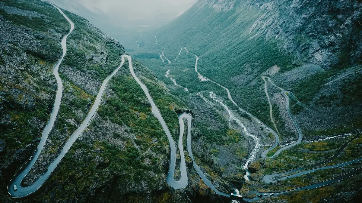
Few parts of Norway combine dramatic mountains, deep valleys, fjords, railway journeys and spectacular roads as closely as the Romsdalen region.
At its centre is Åndalsnes, a small town surrounded by some of Norway's most impressive mountain scenery. From here, travellers can reach Rampestreken, Romsdalseggen, Trollveggen and the famous Trollstigen mountain road.
Further west, Molde adds a completely different experience: a relaxed fjord city known for roses, culture and its famous panorama of mountain peaks. The region is particularly rewarding for road-trippers, hikers, photographers and travellers who want to combine several major Norwegian experiences in one journey.
11.1 Romsdalen at a Glance
- Region: Møre og Romsdal
- Main base: Åndalsnes
- Major city: Molde
- Landscape: Mountains, valleys, fjords, waterfalls and coastline
- Best for: Hiking, scenic driving, photography, trains, road trips and outdoor adventure
Major highlights: Åndalsnes, Rampestreken, Romsdalstrappa, Nesaksla, Romsdalseggen, Romsdalsgondolen, Trollveggen, Trollstigen, Isterdalen, Valldal, Gudbrandsjuvet, Molde, Varden–Molde Panorama, Romsdal Museum, Atlantic Road, Bud, Hustadvika.
Åndalsnes is often described as Norway's mountaineering capital, with both relatively accessible viewpoints and demanding mountain routes.
11.2 Åndalsnes — Norway's Mountaineering Town
Åndalsnes sits at the head of the Romsdalsfjord, surrounded by dramatic peaks.
The town itself is compact and easy to explore, but its greatest attraction is the landscape around it.
You can spend one day walking to a famous viewpoint, another day taking the train through the valley, and another exploring the surrounding mountain roads.
Why stay in Åndalsnes? It is an excellent base for: Rampestreken, Romsdalseggen, Trollveggen, Trollstigen, Romsdalsgondolen, Rauma Railway, mountain hiking, climbing, kayaking, scenic road trips.
The town is also strategically positioned between several major destinations in Western Norway.
11.3 Rampestreken
Rampestreken is one of the most recognisable viewpoints in the Romsdalen region.
The steel viewing platform projects dramatically from the mountainside above Åndalsnes.
It provides views across: Åndalsnes, Romsdalsfjord, surrounding mountains, the Romsdalen valley.
The viewpoint is approximately 537 metres above sea level.
Hiking to Rampestreken: the usual route starts from Åndalsnes and climbs via the Romsdalstrappa. The trail includes natural terrain and stone steps constructed by Nepalese Sherpas.
Allow roughly 1.5 hours for the ascent, depending on fitness and pace. The terrain can become slippery, particularly in wet or winter conditions, so sturdy footwear is important.
Continue to Nesaksla: if you still have energy, continue beyond Rampestreken toward Nesaksla. At the top you can find panoramic views, Eggen Restaurant, Romsdalsgondolen. The gondola provides an alternative way to return to Åndalsnes.
Photography tip: 1. Arrive early or later in the day. 2. Watch for changing weather. 3. Use a wide-angle lens if available. 4. Include the fjord and mountains behind the platform. 5. Avoid standing too close to exposed edges.
11.4 Romsdalsgondolen
The Romsdalsgondolen connects Åndalsnes with Nesaksla.
The journey is approximately 1,679 metres along the cable line, taking travellers from the fjord level toward the mountain viewpoint.
At the upper station, visitors can enjoy: panoramic views, Eggen Restaurant, hiking trails, access to Rampestreken.
Who should consider the gondola? It is particularly useful for families, travellers with limited hiking time, photographers, visitors who want mountain views without completing a demanding climb.
Always check operating hours, weather restrictions and current prices before travelling.
11.5 Romsdalseggen Ridge
For experienced hikers, Romsdalseggen is one of the major attractions of the region.
The ridge provides spectacular views toward: Trollveggen, Romsdalshorn, Åndalsnes, Romsdalsfjord, surrounding mountain ranges, the coastline toward Molde.
The official route description lists the hike at approximately 10.3 km, with around 970 metres of ascent, and classifies it as demanding. Good fitness and experience with steep, uneven terrain are important.
What makes Romsdalseggen special? Unlike a viewpoint reached by a short walk, Romsdalseggen is an actual mountain adventure.
Expect: steep sections, rocky terrain, exposed ridge sections, changing weather, long hiking time, significant elevation gain.
Important: do not choose Romsdalseggen simply because photographs look attractive. Mountain conditions can change quickly. Check weather, trail conditions, daylight, water availability, transport to the trailhead, your own fitness.
The official route description notes that the terrain includes exposed and rocky sections.
11.6 Easier Alternative — Litlefjellet
If Romsdalseggen is too demanding, consider Litlefjellet.
It offers impressive views while requiring considerably less time.
Visit Norway describes the hike as a much easier option, with roughly half an hour from the car park to the summit and about an hour for the return journey, depending on conditions and pace.
This makes Litlefjellet useful for: families with older children, travellers with limited time, photographers, visitors who want a mountain experience without committing to a full-day ridge hike.
11.7 Trollveggen — The Troll Wall
Trollveggen is one of the defining landmarks of Romsdalen.
The enormous vertical rock face dominates the valley and has become internationally associated with climbing and mountaineering.
The landscape can be viewed from several points around the Romsdalen valley, and the Rauma Railway also passes through the area.
Visit Norway describes Trollveggen as Europe's highest perpendicular rock face.
Trollveggen Visitor Area: a stop at Trollveggen works well as part of a road trip between Åndalsnes → Trollveggen → Isterdalen → Trollstigen.
Allow time for photographs and to appreciate the scale of the mountains.
Photography tip: use a person, vehicle or other small object in the foreground when possible. This helps communicate the enormous scale of the cliff.
11.8 Rauma Railway — One of Norway's Great Train Journeys
The Rauma Railway (Raumabanen) connects Dombås with Åndalsnes. The journey passes through a spectacular mountain landscape of valleys, rivers, bridges, waterfalls, steep mountain walls, Trollveggen.
The railway arrives directly in Åndalsnes, close to the Romsdalsgondolen.
Why take the train? A train journey provides an excellent alternative to driving. You can relax instead of navigating mountain roads, photograph the landscape, combine train travel with hiking, connect with the wider Norwegian railway network.
Suggested experience: Oslo → Dombås → Åndalsnes. This can become an excellent scenic alternative to a purely road-based itinerary.
Always check current train schedules with the official transport providers before booking.
11.9 Trollstigen
Trollstigen is one of Norway's most famous mountain roads.
The road connects the Romsdalen area with Valldal and forms part of the Norwegian Scenic Route Geiranger–Trollstigen.
The road is famous for its eleven hairpin bends, steep mountain landscape, waterfalls, dramatic viewpoints, narrow mountain road.
The road officially opened in 1936.
Important Planning Note
Trollstigen's road status has been affected by rockfall and safety work.
In autumn 2026 the Norwegian Scenic Routes website reported that the Trollstigen road section was closed for the rest of the year because of rockfall.
Viewpoints on the Valldal side may still be reachable when the pass itself is closed, but access depends on the current road information.
Do not assume the mountain pass will be open. Check the latest road status at vegvesen.no/trafikk or by calling 175 before travelling.
This is particularly important if your itinerary depends on driving Åndalsnes → Trollstigen → Valldal.
11.10 Trollstigen Viewpoints
Even when the mountain road itself is affected by closures, the Trollstigen viewpoint area can remain a major attraction.
The main viewing platform extends over the mountainside approximately 200 metres above the road below.
The site includes: viewing platforms, walking paths, steps, dramatic mountain views, information facilities, seasonal toilets.
Some areas are partially wheelchair accessible.
Best time for photography: morning and evening can provide softer light. For dramatic weather photography, cloudy conditions can sometimes create a stronger atmosphere than a completely clear sky.
Always remain on designated paths.
11.11 Isterdalen
Isterdalen is the valley leading toward Trollstigen from the Åndalsnes side.
The valley is surrounded by dramatic peaks and provides a completely different perspective of the mountains.
It is worth visiting even if road conditions prevent a full Trollstigen crossing.
Ideal for: landscape photography, short stops, road-trip photography, viewing the surrounding mountains, combining with Trollveggen.
11.12 Valldal
On the opposite side of Trollstigen lies Valldal, a fertile valley famous for its agricultural landscape and especially strawberries.
Valldal can be combined with: Trollstigen, Geiranger, Tafjord, fjord cruises, mountain hikes.
It is also an important alternative access point for the Trollstigen Plateau when the road from Åndalsnes is closed.
11.13 Gudbrandsjuvet
Gudbrandsjuvet is a dramatic gorge along the Geiranger–Trollstigen Scenic Route.
The river has carved a narrow passage through the rock, producing powerful water movement and distinctive geological formations.
The site works particularly well as a short scenic stop during a road trip.
Suggested combination: Valldal → Gudbrandsjuvet → Trollstigen Plateau. Check road conditions before setting out.
11.14 Molde — The City of Roses
Molde sits beside the Romsdalsfjord and offers a more relaxed urban experience after the mountains of Åndalsnes.
The city is known for: roses, fjord views, culture, jazz, museums, mountain panoramas.
Molde is also close to both the Atlantic Road and the Geiranger–Trollstigen region.
11.15 Varden — Molde Panorama
One of Molde's most famous viewpoints is Varden.
At approximately 407 metres above sea level, the viewpoint offers panoramic views over: Molde, Romsdalsfjord, islands, surrounding mountains.
The famous Molde Panorama is associated with views of approximately 222 mountain peaks.
Photography tip: Varden is particularly useful near sunset or during clear weather when the mountain panorama becomes easier to distinguish.
11.16 Romsdal Museum
The Romsdal Museum provides an opportunity to learn about regional history and traditional Norwegian life.
It is particularly useful for travellers who want something beyond mountains and viewpoints.
Combine it with: Molde city centre, Varden, harbour, cafés, local restaurants.
11.17 Molde International Jazz Festival
Molde is internationally associated with the Molde International Jazz Festival.
The festival is a major cultural event and is described by Visit Norway as the world's oldest jazz festival in continuous operation.
If your trip coincides with the festival period, accommodation demand can be considerably different from ordinary summer travel.
Booking tip: if visiting Molde during a major festival, book accommodation and transport well in advance.
11.18 The Atlantic Road
The Atlantic Road (Atlanterhavsvegen) is one of Norway's most famous scenic drives.
The official Norwegian Scenic Route is approximately 36 km long, running between Kårvåg and Bud.
Its signature feature is a series of bridges connecting small islands and skerries across the exposed coastline.
The route includes seven bridges and several purpose-built viewpoints and rest areas.
11.19 Atlantic Road Highlights
Storseisundbrua — the largest and most recognisable bridge is one of the classic photographic symbols of the Atlantic Road.
Eldhusøya — features an elevated circular walking path around the island. The path is wheelchair accessible and remains open throughout the year according to the National Scenic Routes information.
Myrbærholmbrua — a popular location for fishing and ocean views.
Askevågen — a small viewpoint providing close contact with the Atlantic landscape.
Kjeksa — located near Bud, offers views toward the ocean and Hustadvika.
Bud — the historic fishing village of Bud forms the western end of the official Scenic Route. From here, travellers can continue toward Molde.
11.20 Hustadvika
The Atlantic Road runs beside Hustadvika, an exposed and historically challenging stretch of coastline.
Weather can dramatically change the appearance of this landscape.
On a calm summer day, the area can appear peaceful. During rough weather, the same coastline can demonstrate the full power of the Atlantic.
Safety: do not approach breaking waves unnecessarily. Rock platforms can become extremely slippery when wet, and large waves can reach areas that appear safe during calm weather.
11.21 Bud
Bud is a traditional fishing village with coastal scenery and historical connections to fishing and maritime activity.
It is an excellent place to slow down after driving the Atlantic Road.
Suggested activities: harbour walk, seafood meal, coastal photography, Kjeksa viewpoint, Ergan Coastal Fort area, continue toward Molde.
11.22 Outdoor Activities
Hiking — easier: Litlefjellet, viewpoint walks. Moderate: Rampestreken/Nesaksla. Demanding: Romsdalseggen.
Cycling — the Atlantic Road can be explored by bicycle, but strong winds are possible, particularly across bridges.
Kayaking — fjords around Romsdalen and the wider Northwest region offer opportunities for kayaking. Always check wind, waves, water temperature, local regulations, experience level.
Climbing — Romsdalen has a long climbing and mountaineering tradition, particularly around the major mountain walls. Less experienced visitors should use qualified local guides for technical terrain.
11.23 Suggested 2-Day Itinerary
Day 1 — Åndalsnes: Morning — arrive in Åndalsnes, explore the town, visit Norsk Tindesenter. Late morning/afternoon — choose one: Rampestreken, Romsdalsgondolen, Litlefjellet. Evening — dinner in Åndalsnes, relax beside the fjord.
Day 2 — Trollveggen & Trollstigen Area: Morning — drive toward Trollveggen, photography stop, continue toward Isterdalen. Then check the current Trollstigen road situation. If open: Isterdalen → Trollstigen → Valldal. If closed: use an alternative route and access the Trollstigen Plateau from the permitted side where available.
11.24 Suggested 3-Day Itinerary
- Day 1: Åndalsnes + Rampestreken + Romsdalsgondolen.
- Day 2: Trollveggen + Isterdalen + Trollstigen area.
- Day 3: Molde + Varden + Romsdal Museum.
11.25 Suggested 5-Day Itinerary
- Day 1: Arrive Åndalsnes.
- Day 2: Romsdalseggen or alternative mountain hike.
- Day 3: Trollveggen + Trollstigen + Valldal.
- Day 4: Drive toward Molde.
- Day 5: Molde + Atlantic Road + Bud.
This five-day version allows significantly more flexibility for weather.
11.26 Suggested 7-Day Northwest Road Trip
- Day 1: Ålesund → Åndalsnes.
- Day 2: Åndalsnes + Rampestreken.
- Day 3: Romsdalseggen/mountain day.
- Day 4: Trollveggen + Trollstigen area.
- Day 5: Valldal → Geiranger.
- Day 6: Geiranger → Molde.
- Day 7: Molde → Atlantic Road → Bud → onward travel.
This itinerary can be adjusted depending on the opening status of mountain roads and ferries.
11.27 Best Time to Visit
May — spring scenery begins to develop, but mountain roads and hiking routes can still have snow.
June — long days, waterfalls and increasingly accessible hiking.
July–August — peak summer season. Expect more visitors, busier roads, higher accommodation demand, longer queues at popular viewpoints.
September — excellent for photography and autumn colours, although daylight becomes shorter.
October–April — the region changes dramatically. Expect snow, icy roads, shorter daylight, possible road closures, winter hiking conditions.
Trollstigen is a mountain road, so seasonal access should always be checked before travel.
11.28 Weather & Mountain Safety
Romsdalen is a mountain environment. Conditions can change rapidly.
Before hiking: check the weather forecast, check trail conditions, tell someone your plans, carry sufficient water, wear suitable footwear, take warm and waterproof clothing, carry a charged phone, allow extra time, turn around if conditions become unsafe.
Remember: a sunny morning in Åndalsnes does not guarantee good weather at higher elevation.
11.29 Driving in the Region
Mountain roads can include: narrow lanes, steep gradients, hairpin bends, tunnels, cyclists, pedestrians, tourist traffic, buses and motorhomes.
Driving checklist: check road status, check ferry schedules, fill the fuel tank before remote sections, allow extra time, keep distance from other vehicles, do not stop in unsafe locations for photographs, respect passing places, watch for cyclists, check weather before mountain crossings.
Trollstigen reminder: never build an itinerary around Trollstigen without checking the latest official road status immediately before travelling.
11.30 Food & Local Experiences
The Romsdal and Northwest region offers opportunities to try: Norwegian seafood, salmon, cod, locally sourced meat, traditional baked goods, berries, Norwegian coffee culture.
Valldal is particularly associated with local agricultural production and strawberries.
In coastal areas such as Bud and the Atlantic Road, seafood is a natural choice.
11.31 Accommodation Strategy
Åndalsnes — best for: hiking, Trollveggen, Trollstigen, train travel, mountain activities.
Valldal — best for: Trollstigen, Geiranger, fjord activities, road trips.
Molde — best for: city facilities, restaurants, Atlantic Road, cultural attractions, longer stays.
Camping — camping can be an excellent option during summer, but always follow local rules and use designated facilities where required.
11.32 Photography Guide
Åndalsnes: Romsdalsfjord, mountain skyline, Rampestreken.
- Romsdalen: Trollveggen, valley landscapes, waterfalls.
- Trollstigen: hairpin road, viewpoint, mountains.
- Molde: Varden panorama, fjord, mountain skyline.
- Atlantic Road: Storseisundbrua, ocean, sunset, storm conditions.
- Camera settings: use a low ISO when possible, keep the horizon level, use a tripod for low-light scenes, protect equipment from rain and sea spray.
A smartphone can produce excellent results if you use good light and carefully compose the scene.
11.33 Suggested Routes
- Main route: Åndalsnes → Trollveggen → Isterdalen → Trollstigen → Valldal.
- Western extension: Åndalsnes → Molde → Atlantic Road → Bud.
- Key stops: Åndalsnes, Rampestreken, Romsdalsgondolen, Trollveggen, Isterdalen, Trollstigen, Valldal, Gudbrandsjuvet, Molde, Varden, Atlantic Road, Bud.
11.35 Budget Guide
Budget traveller — hostel/shared accommodation, supermarket meals, public transport, selected free viewpoints, self-guided hikes.
Mid-range traveller — hotel/private room, restaurant meals, rental car, gondola, selected paid attractions.
Premium traveller — higher-end hotels, private guides, scenic excursions, premium restaurants, organised outdoor experiences.
11.37 Responsible Travel
The mountains and coastline around Romsdalen are fragile.
Follow these principles: stay on marked trails, do not leave rubbish, avoid disturbing wildlife, respect private property, use designated parking areas, do not block roads for photographs, follow local camping regulations, keep noise low in natural areas, leave cultural and historic sites undisturbed.
On mountain hikes, your safety is also part of responsible travel. Do not attempt a demanding route simply because it is popular online.
11.38 Accessibility
Not every attraction in Romsdalen is suitable for every visitor.
The region contains steep mountains, stairs and uneven terrain.
However, some attractions offer easier access, including: selected viewpoint areas, parts of Trollstigen, Romsdalsgondolen, Eldhusøya on the Atlantic Road.
Eldhusøya's elevated circular path is specifically described as wheelchair accessible.
Always check current accessibility information before travelling because weather, construction and seasonal conditions can affect access.
11.39 Check Before You Go
Before travelling to Romsdalen, check: Trollstigen road status, Norwegian Scenic Routes updates, mountain weather, hiking conditions, Romsdalsgondolen opening times, Rauma Railway timetable, ferry schedules, accommodation availability, road restrictions, seasonal attraction opening hours, parking information, local weather warnings.
Most important: do not assume that a road or attraction operating in one year will operate under identical conditions in the next.
11.40 Quick Reference
| Åndalsnes town | 1–3 hours | easy |
|---|---|---|
| Rampestreken | 2–3 hours | moderate |
| Romsdalsgondolen | 1–3 hours | easy |
| Litlefjellet | ~1–2 hours | moderate |
| Romsdalseggen | full day | demanding |
| Trollveggen | 30–60 min | easy |
| Trollstigen viewpoints | 1–2 hours | easy |
| Gudbrandsjuvet | 30–60 min | easy |
| Varden | 30–60 min | easy |
| Romsdal Museum | 1–2 hours | easy |
| Atlantic Road | half day+ | easy |
| Bud | 1–2 hours | easy |
11.41 The Perfect Romsdal Combination
For first-time visitors with limited time, a strong combination is:
Åndalsnes → Rampestreken → Trollveggen → Trollstigen area → Molde → Atlantic Road → Bud
This route combines mountain scenery, hiking, fjords, engineering, scenic roads, coastal landscapes, cultural experiences.
The exact route should be adjusted according to current road conditions, weather and seasonal access.
11.42 Final Takeaway
Romsdalen is one of the places where Norway's landscapes feel particularly concentrated.
In a relatively small area, travellers can experience high mountains + deep fjords + dramatic roads + historic railways + coastal scenery + vibrant towns.
Åndalsnes is the natural adventure base. Trollveggen provides the drama. Trollstigen provides the iconic mountain-road experience when conditions and road status allow. Molde provides culture, comfort and panoramic views. And the Atlantic Road adds a completely different landscape where road and ocean meet.
This region deserves several days of a Norway itinerary rather than a rushed stop.