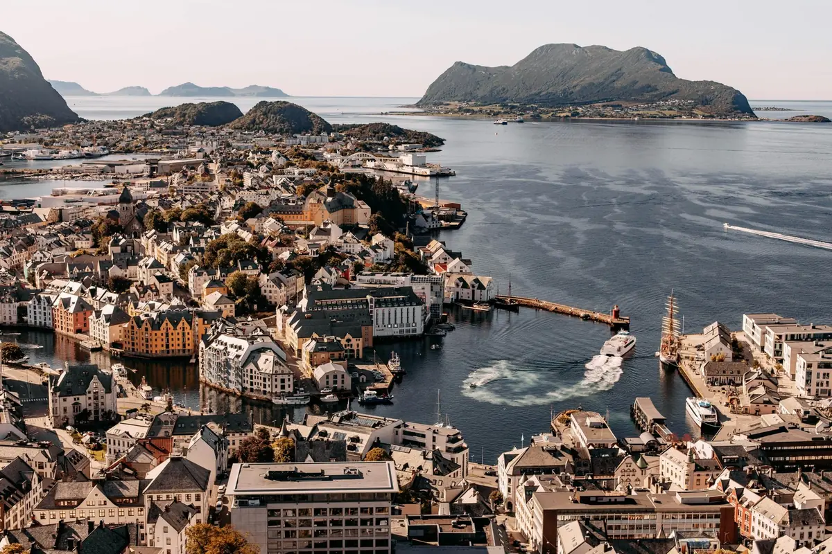
Few places combine city, ocean, mountains and fjords as dramatically as Ålesund and Sunnmøre.
Ålesund is famous for its distinctive Art Nouveau architecture and its position across several islands facing the Atlantic. The surrounding Sunnmøre region provides access to spectacular mountains, fjords, islands and coastal landscapes. It is also one of the main gateways to the Geirangerfjord, a UNESCO World Heritage site.
For travellers, this region offers an unusual combination: beautiful city → panoramic viewpoint → coastal islands → alpine mountains → dramatic fjords → scenic road trip.
6.1 Ålesund at a Glance
- Region: Møre og Romsdal
- Location: Western Norway
- Ideal stay: 2–3 days
- Best for: Architecture, photography, fjords, hiking, islands, food and road trips
Ålesund is spread across several islands and has the Atlantic Ocean on its doorstep. The city is also surrounded by the Sunnmøre Alps and is a convenient starting point for exploring the Geirangerfjord and Hjørundfjord.
Ideal for: couples, families, cruise travellers, photographers, road trippers, hikers, architecture lovers, fjord travellers.
6.2 Why Is Ålesund Famous?
The answer is Art Nouveau architecture.
A major fire destroyed much of central Ålesund in 1904. When the city was rebuilt, many buildings were constructed in the Art Nouveau style popular in Europe at the beginning of the twentieth century.
The result is a city centre filled with: decorative façades, turrets, spires, ornamental details, colourful buildings, distinctive windows, stone and brick architecture.
Today, Ålesund is regarded as one of Norway's most distinctive architectural cities.
6.3 Walking Through Ålesund
One of the best ways to experience Ålesund is simply to walk.
A good introductory route is: Cruise Harbour → Kongens gate → Brosundet → Apotekergata → Art Nouveau Centre → Aksla.
Along the way, look upwards. Many of the most interesting details are above street level.
Look for: animal sculptures, floral decorations, towers, curved windows, ornamental doorways, Art Nouveau motifs.
6.4 Brosundet
Brosundet is the waterway running through the heart of Ålesund.
The combination of water, boats, bridges, Art Nouveau buildings, restaurants and mountain views makes it one of the city's best photography areas.
Kayaking is also possible in and around the waterways of Ålesund, providing a completely different perspective of the architecture.
Photography tip: visit early in the morning when the water is calm. The buildings can create beautiful reflections in the canal.
6.5 Mount Aksla — The Classic Ålesund View
If you see only one viewpoint in Ålesund, make it Aksla.
From the viewpoint you can see: Ålesund city, islands, Atlantic Ocean, Sunnmøre Alps, surrounding waterways.
The famous Fjellstua viewpoint sits on Aksla.
Visitors can reach the viewpoint by road or climb the famous staircase from the city centre. The staircase from Byparken contains 418 steps.
The reward: at the top, the entire city opens out below you — one of the best photo viewpoints in Norway.
6.6 Best Time for Aksla
- Morning — good for: softer light, fewer visitors, clearer city photography.
- Afternoon — good for: general sightseeing, longer daylight, combining Aksla with city attractions.
- Evening — potentially excellent for: sunset, golden-hour photography, city lights.
Weather determines the actual quality of the view, so check visibility before making a special trip.
6.7 Fjellstua
At the top of Aksla is Fjellstua, a historic viewpoint and dining location.
It provides panoramic views across Ålesund, the surrounding islands, the Sunnmøre Alps and the sea.
Travellers can combine: city walk → 418 steps → viewpoint → coffee/meal → return to city.
This makes Aksla particularly easy to include in a one-day itinerary.
6.8 The Art Nouveau Centre & KUBE
For travellers who want to understand why Ålesund looks the way it does, visit the Art Nouveau Centre & KUBE.
The centre is located in the historic Swan Pharmacy building from 1907 and focuses on Ålesund's Art Nouveau heritage.
Why visit? It helps explain: the 1904 fire, the rebuilding of Ålesund, Art Nouveau architecture, design details, the city's cultural history.
Recommended combination: visit the museum first, then walk through the city and identify the architectural features you have just learned about.
6.9 Atlanterhavsparken
Atlanterhavsparken is Ålesund's major aquarium and marine attraction. It is located at Tueneset on the coast and focuses on marine life from the Norwegian coast and the Atlantic Ocean.
Good for: families, children, marine-life enthusiasts, rainy days, visitors travelling without a major hiking plan.
Allow enough time to explore the exhibits rather than treating it as a quick photo stop.
6.10 Alnes Lighthouse
For a completely different landscape, travel to Alnes on Godøya island.
The historic lighthouse stands beside the Atlantic Ocean in a dramatic coastal setting.
The lighthouse has operated for ships since 1853, and the surrounding landscape provides excellent opportunities for coastal photography.
Experience: combine Ålesund → island drive → Alnes → lighthouse → coastal walk → sunset. Alnes can be particularly beautiful in the evening.
6.11 Runde — The Bird Island
The island of Runde is another possible excursion from the Ålesund region.
Runde is particularly known for its birdlife and dramatic coastal landscape.
Depending on the season and current local conditions, visitors may be able to see seabirds such as puffins and other species.
The area is best suited to travellers who have an additional day available rather than visitors attempting to see Ålesund in a few hours.
6.12 Hjørundfjord & Sunnmøre Alps
The landscape around Ålesund changes dramatically as you move inland.
The Sunnmøre Alps rise sharply around the fjords, creating some of the most spectacular mountain scenery in western Norway.
The mountains include peaks rising to around 1,700 metres above the Atlantic landscape.
Popular activities: hiking, ski touring, kayaking, fjord cruises, photography, scenic drives.
For experienced hikers, peaks such as Slogen offer dramatic views over Hjørundfjord.
6.13 Geirangerfjord — Norway's Iconic Fjord
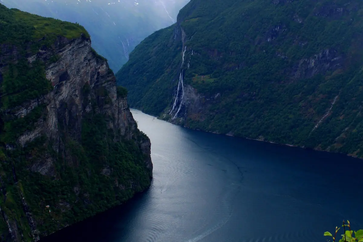
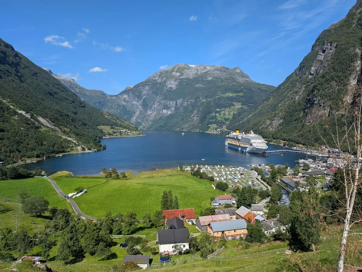
The Geirangerfjord is one of the defining landscapes of Norway.
It is a UNESCO World Heritage site and is surrounded by steep mountains, waterfalls, historic farms and deep blue-green water.
The fjord was shaped by repeated glacial activity over geological time.
Today, visitors can explore it by: fjord cruise, ferry, kayak, RIB, hiking, scenic driving.
6.14 The Seven Sisters
One of Geirangerfjord's most famous sights is De Syv Søstrene — The Seven Sisters.
Seven narrow waterfalls descend the mountainside directly towards the fjord.
Opposite them is The Suitor, or Friaren. Another famous waterfall is The Bridal Veil.
These waterfalls are best appreciated from the water, although they can also be viewed from selected viewpoints.
Photography tip: a fjord cruise allows you to understand the scale of the waterfalls much better than viewing them from land.
6.15 Geirangerfjord Cruise
A cruise is one of the easiest ways to experience the fjord.
During a typical cruise, travellers can see: Seven Sisters, The Suitor, Bridal Veil, abandoned mountain farms, steep cliffs, waterfalls, small settlements, wildlife.
Cruises also provide opportunities to see historic farms such as Skageflå and Knivsflå from the water.
Cruise options: standard fjord cruise (first-time visitors), ferry (travellers combining transport and sightseeing), RIB (adventure travellers), kayak (active travellers), cruise + hike (outdoor enthusiasts).
6.16 Skageflå
One of the most famous historic mountain farms in the Geirangerfjord area is Skageflå.
The farm sits high above the fjord and can be reached through a steep hiking route combined with a boat transfer.
It provides an excellent example of how people historically lived and farmed on extremely steep mountain slopes.
Important: the route is steep and should not be treated as an easy sightseeing walk. Check weather, trail conditions, fitness requirements, boat timetable, return arrangements before starting.
6.17 Flydalsjuvet
Just outside Geiranger is Flydalsjuvet, one of the area's best-known viewpoints.
From here you can look down towards: Geiranger, Geirangerfjord, surrounding mountains.
It is particularly popular with photographers.
Road-trip stop: Flydalsjuvet is an easy addition to a Geiranger road trip. Allow approximately 20–45 minutes for the viewpoint, walking and photography.
6.18 Dalsnibba & Geiranger Skywalk
For an even higher viewpoint, continue towards Dalsnibba.
The Geiranger Skywalk sits at approximately 1,500 metres above sea level and provides a dramatic view towards Geirangerfjord.
The final road section, Nibbevegen, is a private toll road and is normally closed during winter conditions.
Important: do not assume Dalsnibba is accessible simply because Geiranger itself is open. Check road status, snow, weather, visibility, opening dates before travelling.
6.19 Ørnevegen & Ørnesvingen
The road between Geiranger and Eidsdal includes the famous Ørnevegen, or Eagle Road.
It contains 11 hairpin bends climbing the mountainside.
At the top is Ørnesvingen, a spectacular viewpoint overlooking: Geiranger, Geirangerfjord, Seven Sisters, Knivsflå, surrounding mountains.
The viewpoint itself includes a waterfall and a designed viewing platform.
Photography tip: this is one of the best places to photograph the relationship between the fjord, waterfalls and mountain farms.
6.20 Geiranger Village
The village of Geiranger is small but strategically important.
It is the natural base for exploring: fjord cruises, Flydalsjuvet, Dalsnibba, Ørnesvingen, Fosseråsa, Storsæterfossen, Skageflå.
The village also has restaurants, accommodation, visitor facilities and the Norwegian Fjord Centre.
6.21 Norwegian Fjord Centre
Before exploring the fjord, consider visiting the Norwegian Fjord Centre.
It introduces visitors to: the formation of fjords, Geiranger's natural environment, World Heritage status, local history, life in the fjord landscape.
It can make the later cruise or hike much more meaningful because you understand the landscape you are looking at.
6.22 Fosseråsa & Storsæterfossen
The Fosseråsa National Hiking Trail starts in Geiranger and leads towards the Storsæter waterfall.
One of the memorable features of the route is the opportunity to get close to, and in suitable conditions walk behind, the waterfall.
Suitable for: hikers, nature photographers, waterfall lovers, travellers staying overnight in Geiranger.
Check current trail conditions before setting out.
6.23 Geiranger–Trollstigen Scenic Route
One of Norway's most spectacular road trips is the Norwegian Scenic Route Geiranger–Trollstigen.
The official route is approximately 104 kilometres long and reaches elevations from sea level to around 1,038 metres. It includes one ferry crossing between Eidsdal and Linge.
Major highlights include: Geiranger, Ørnesvingen, Eidsdal, Linge, Gudbrandsjuvet, Trollstigen.
6.24 Trollstigen — The Road of Eleven Hairpin Bends
Trollstigen is one of Norway's most recognisable mountain roads.
The road climbs dramatically through the mountains using a series of hairpin bends.
At the Trollstigen viewpoint, a large architectural viewing platform projects over the landscape approximately 200 metres above the road.
The viewpoint is itself an example of modern Norwegian landscape architecture.
6.25 Important Trollstigen Safety Update
Trollstigen's road conditions can change because of rockfalls and weather.
In autumn 2026 the Norwegian Scenic Routes website reported that the Trollstigen road section was closed for the rest of the year because of rockfall.
Do not assume that Trollstigen is open: the road has seasonal closures and, recently, rockfall closures.
Before travelling, check the latest road status at vegvesen.no/trafikk or by calling 175.
6.26 Gudbrandsjuvet
Another spectacular stop on the Scenic Route is Gudbrandsjuvet.
The Valldøla River has carved deep formations and potholes into the rock over thousands of years.
The modern viewing platform allows visitors to look directly into the gorge.
Suggested stop: 30–60 minutes is enough for most visitors to walk around the viewpoint and take photographs.
6.27 The Complete Ålesund–Geiranger Experience
For travellers with enough time, a fantastic regional journey is:
Ålesund → Alnes → Hjørundfjord/Sunnmøre → Geiranger → Geirangerfjord Cruise → Flydalsjuvet → Dalsnibba → Ørnesvingen → Eidsdal → Valldal → Gudbrandsjuvet → Trollstigen → Åndalsnes
Treat this as a multi-day scenic journey, not as a rushed single-day drive.
6.28 A Perfect 1-Day Ålesund Itinerary
- Morning: 08:30 Breakfast, 09:00 Walk through Art Nouveau centre, 10:00 Brosundet, 11:00 Art Nouveau Centre & KUBE.
- Afternoon: 12:30 Lunch, 14:00 Aksla, 15:30 Return to city centre, 16:00 Harbour.
- Evening: 18:00 Dinner, 19:30 Waterfront walk, 20:00 Sunset photography if conditions are suitable.
6.29 A Perfect 2-Day Ålesund Itinerary
Day 1 — Ålesund: Art Nouveau centre, Brosundet, city centre, Aksla, Fjellstua, harbour, evening meal.
Day 2 — Coast & Islands: choose Option A: Alnes Lighthouse; Option B: Runde; Option C: Atlanterhavsparken + coastal walk; Option D: Hjørundfjord experience. Choose according to weather, transport and available time.
6.30 A Perfect 3-Day Geiranger Itinerary
- Day 1 — Ålesund: explore the city and Aksla.
- Day 2 — Geiranger: travel towards Geiranger. Visit Geiranger village, Norwegian Fjord Centre, Flydalsjuvet, Dalsnibba (if accessible).
- Day 3 — Fjord: take a fjord cruise. See Seven Sisters, The Suitor, Bridal Veil, historic fjord farms. If conditions and fitness allow, add a hiking experience.
6.31 A Perfect 4-Day Road Trip
- Day 1: Ålesund.
- Day 2: Ålesund → Geiranger.
- Day 3: Geirangerfjord + Dalsnibba + Ørnesvingen.
- Day 4: Eidsdal → Valldal → Gudbrandsjuvet → Trollstigen → Åndalsnes.
This is an excellent option for travellers renting a car.
However, the actual route must be checked shortly before travel because mountain roads and ferry services are weather-dependent. The official Scenic Route information should be treated as the final authority.
6.32 Driving Tips
Norwegian mountain roads require patience.
Expect: narrow sections, hairpin bends, tunnels, ferries, cyclists, motorhomes, tourist buses, sudden weather changes.
Important: do not plan a mountain road trip using only Google Maps' estimated driving time. Allow extra time for photography, traffic, ferry waiting, roadworks, weather, viewpoints.
The Scenic Route itself recommends allowing enough time for stops rather than simply driving through.
6.33 Public Transport & Tours
Travellers without a car can still explore the region.
Options may include: regional buses, ferries, fjord cruises, organised sightseeing tours, guided hiking, boat transfers.
Ålesund Tourist Information provides maps, advice and bookings for experiences including Geiranger, Hjørundfjord, Alnes and Runde.
Always check current timetables before planning a connection.
6.34 Best Season
Summer — best for: long daylight, road trips, fjord cruises, hiking, open mountain roads.
Spring — potentially beautiful because of: waterfalls, fresh green vegetation, snow-covered mountains. However, some mountain roads and attractions may still have seasonal restrictions.
Autumn — excellent for: autumn colours, fewer visitors, photography, dramatic weather.
Winter — Ålesund remains accessible, but many mountain roads and viewpoints can have seasonal restrictions. Geiranger can also be experienced in winter, but the itinerary needs much more careful planning. Visit Norway highlights winter experiences in the Geirangerfjord area as well.
6.35 What to Pack
For an Ålesund and Geiranger trip: waterproof jacket, warm mid-layer, hiking shoes, comfortable walking shoes, gloves, hat, water bottle, power bank, camera, sunglasses, small backpack.
For mountain hikes, add appropriate hiking equipment according to the route and season.
6.36 Photography Guide
Ålesund — best subjects: Art Nouveau buildings, Brosundet, Aksla panorama, harbour, fishing boats, Alnes lighthouse.
Geiranger — best subjects: Seven Sisters, fjord from the water, Flydalsjuvet, Dalsnibba, Ørnesvingen, mountain farms, waterfalls.
Road Trip — best subjects: Trollstigen, Gudbrandsjuvet, mountain roads, fjord viewpoints, scenic ferry crossings.
6.37 Suggested Routes
Route 1 — Ålesund: Ålesund centre → Brosundet → Aksla → Atlanterhavsparken → Alnes.
Route 2 — Geiranger: Geiranger → Flydalsjuvet → Dalsnibba → Ørnesvingen → Seven Sisters.
Route 3 — scenic road trip: Geiranger → Eidsdal → Linge → Valldal → Gudbrandsjuvet → Trollstigen → Åndalsnes.
6.39 Ålesund & Geiranger Quick Reference
| Ålesund city centre | 2–3 hrs | architecture |
|---|---|---|
| Brosundet | 30–60 min | photography |
| Aksla | 1–2 hrs | panorama |
| Art Nouveau Centre | 1–2 hrs | history |
| Atlanterhavsparken | 2–3 hrs | families |
| Alnes | 2–4 hrs | coast/sunset |
| Geiranger village | 1–2 hrs | base/sightseeing |
| Fjord cruise | 2–4 hrs | waterfalls |
| Flydalsjuvet | 20–45 min | photography |
| Dalsnibba | 1–2 hrs | mountain panorama |
| Ørnesvingen | 20–45 min | fjord views |
| Gudbrandsjuvet | 30–60 min | nature |
| Trollstigen | 1–2 hrs | scenic road |
6.41 Check Before You Go
Before you travel, check: opening hours of Ålesund attractions, Aksla/Fjellstua information, aquarium opening hours, Alnes visitor information, Geiranger cruise schedules, Dalsnibba road status, ferry timetables, Ørnevegen and Trollstigen road status, weather, hiking conditions and parking.
Mountain roads and fjord transport are particularly sensitive to weather and seasonal conditions. The official Norwegian Scenic Routes website should be checked immediately before travelling.
6.42 Ålesund & Geirangerfjord in One Sentence
Ålesund combines one of Norway's most distinctive cityscapes with the mountains and fjords of Sunnmøre, while nearby Geirangerfjord delivers the dramatic waterfalls, cliffs and panoramic viewpoints that define the Norwegian fjord experience.
Chapter Summary
Ålesund — Art Nouveau and Atlantic culture. Aksla — the classic city panorama. Alnes — wild Atlantic coastline. Sunnmøre Alps — mountain adventure. Geirangerfjord — UNESCO World Heritage landscape. Seven Sisters — famous fjord waterfalls. Flydalsjuvet — classic viewpoint. Dalsnibba — high mountain panorama. Ørnesvingen — Eagle Road viewpoint. Trollstigen — iconic mountain road. Gudbrandsjuvet — dramatic river gorge.
The journey from Ålesund through Geiranger and towards Trollstigen is not simply transportation between destinations — it is one of the experiences that makes travelling through Western Norway special.